
Source: the Internet Archive version of a copy in the Princeton University Library. The somewhat rough OCR text has been proof-read against the text images, and section headings have been added. — George P. Landow]
Basic geophysical characteristics of Afghanistan
ur readers will endeavour to form a correct idea of the country which before long may be entered by a British army. Afghanistan is, on an average, about 130 miles from east to west, and 460 miles long from south to north. On the north it is bounded by the Oxus till a few miles below Kilat, and thence the boundary line dividing it from Khivan territory runs east and by south to a point afew miles west of Sarrakhs. On the west it is bounded by Persia, on the south by Khelat. From its south-easternmost extremity the frontier runs in a north-easterly direction along British territory as far as Swat. On the east it is bounded by Swat, Kaffiristan, and Kashgar. A glance at the map shows that there is a long narrow promontory, as it were, of Afghan territory, which is bounded on the south by Kaffiristan, on the east by Kashgar, and on the north by some minor khanates, more or less subject to Kokand and Bokhara. At one point this promontory is only 200 miles distant from Cashmere. As, however, we do not anticipate invasion from Afghanistan we may leave out of consideration the above-mentioned tongue of territory. The main features of Afghanistan are the mountain chains, the general direction of which is east and west, but which throw out buttresses to the north and south. Afghanistan is traversed across the centre from east to west by a chain of mountains, which may be viewed as an offshoot of the Himalayan system. This chain, called the Hindoo-Koosh, or more properly the Hindoo-Koh. ends in the Koh-i-Baba, a huge mass north-west of Mid at no great distance from the city of Cabul. It is covered with perpetual snow, and its loftiest peak is nearly 18,000 ft. high. Thence run two parallel chains, one called the Safed Koh; the other——the southernmost one-—the Siah Koh. The northern range terminates just north of Herat; and the southern range, when it reaches a point just south of that city, trends off to the south-west and by south. These mountains are of no great height. North of the Koh-i-Baba the Safod Koh is a high plateau, intersected by minor ranges, and called the Huzareh district. Running in a south-West direction from Cabul past Kandahar to Girishk is another chain of mountains. Practically, almost the whole of Afghanistan is a mass of mountains interspersed with valleys, of which some are of considerable size. The main watersheds of the country are, however, the crests of the two chains which run, one from east to west, and the other diagonally from north-east to south-west.
Afghanistan’s chief rivers
 he chief rivers of Afghanistan are the Murghab, the Heri
Rud, the Balkh, the Cabul, and the Helmund. The Murghab,
rising near the north-eastern extremity of the Safed Koh,
flows to Merv, a little beyond which the stream, whose waters
in its course have been greatly drawn off for purposes of irrigation, loses itself in the sandy desert of Khiva. The Balkh,
rising in the northern slopes of the Koh-i-Babs, is exhausted
in a similar manner soon after it reaches the town of Balkh,
and before it can effect a junction with the Oxus. The Cabul
river rises in the mountains near the city of that Ynanie, lmdi
passing by Jellalabad, makes its way through the Khyber Pass
into British territory, falling into the Indus close to Attock.
The Heri Rud, taking its rise in the north-easterly slopes of the
of the Siah Koh, traverses the long narrow valley
formed by the Safed Koh and the Siah Koh, runs close to and
south of Herat, a few miles past which it turns to the north,
following for some distance the boundary of Afghanistan,
then, quitting that country, turns north-west and falls intro
the Tojend. The Helmund rises in the south-eastern slopes of
the Koh-i-Baba, near Cabul, and, running in a south-westerly
direction to Girisbk, about one hundred miles south of that
city, makes a sudden turn to the west, and, after flowing
in that direction another hundred miles, emerges
Afghan territory. There are other rivers besides those
we have named, but they are of no great import.
As a whole, it may be said that Afghanistan is
well watered, and that in consequence the valleys are
fertile. Unfortunately, we are able to give but scant details
of even the principal rivers. The Murghab is described as a
clear and rapid mountain stream. Of the Balkh river we can
say little. Of the Cabul River we know that from Tezeen the
body of General Elphinstone was, at the end of April sent
down on a raft to Jellalabad. We also know that in the same
month the Cabul River was forded by cavalry with great
difficulty opposite Lalpoora, at the Afghan end of the Khyber
Pass. It is probable, therefore, that the river throughout the
greater part of the course from Cabul to the Indus is navigable
for small boats even m the spring. According to Captain
Marsh, who_ travelled from Meshed to Herat about five
years ago in the month of April, the Heri Rud, where
he crossed_ it at the Afghan frontier, had very little
water in it, benig exhausted by the irrigating canals
higher up. The stream itself was only two yards wide
and 1 ft, deep, but the bed was more than 1000 yards broad.
The piain of Herat is watered by canals from the river and
one of these enters the city. The same author says’that
during the winter, which sets in early and lasts four months
all the streams near Herat are frozen. Concerning the
Hclmund, which would have to be crossed by an army marching from the Bolan to Ilerat, Captain Marsh, who passed it at
Girishk in the beginning of the month of May, says that at
that season it is 100 yards broad and 3% ft. deep. It is then
at its lowest, and split up into many small streams. At the
end of May or beginning of June, when the river is swollen
by the melting of the snow, its breadth is computed at about
a mile. The left, or south bank, is higher than the right, or
northern bank.
he chief rivers of Afghanistan are the Murghab, the Heri
Rud, the Balkh, the Cabul, and the Helmund. The Murghab,
rising near the north-eastern extremity of the Safed Koh,
flows to Merv, a little beyond which the stream, whose waters
in its course have been greatly drawn off for purposes of irrigation, loses itself in the sandy desert of Khiva. The Balkh,
rising in the northern slopes of the Koh-i-Babs, is exhausted
in a similar manner soon after it reaches the town of Balkh,
and before it can effect a junction with the Oxus. The Cabul
river rises in the mountains near the city of that Ynanie, lmdi
passing by Jellalabad, makes its way through the Khyber Pass
into British territory, falling into the Indus close to Attock.
The Heri Rud, taking its rise in the north-easterly slopes of the
of the Siah Koh, traverses the long narrow valley
formed by the Safed Koh and the Siah Koh, runs close to and
south of Herat, a few miles past which it turns to the north,
following for some distance the boundary of Afghanistan,
then, quitting that country, turns north-west and falls intro
the Tojend. The Helmund rises in the south-eastern slopes of
the Koh-i-Baba, near Cabul, and, running in a south-westerly
direction to Girisbk, about one hundred miles south of that
city, makes a sudden turn to the west, and, after flowing
in that direction another hundred miles, emerges
Afghan territory. There are other rivers besides those
we have named, but they are of no great import.
As a whole, it may be said that Afghanistan is
well watered, and that in consequence the valleys are
fertile. Unfortunately, we are able to give but scant details
of even the principal rivers. The Murghab is described as a
clear and rapid mountain stream. Of the Balkh river we can
say little. Of the Cabul River we know that from Tezeen the
body of General Elphinstone was, at the end of April sent
down on a raft to Jellalabad. We also know that in the same
month the Cabul River was forded by cavalry with great
difficulty opposite Lalpoora, at the Afghan end of the Khyber
Pass. It is probable, therefore, that the river throughout the
greater part of the course from Cabul to the Indus is navigable
for small boats even m the spring. According to Captain
Marsh, who_ travelled from Meshed to Herat about five
years ago in the month of April, the Heri Rud, where
he crossed_ it at the Afghan frontier, had very little
water in it, benig exhausted by the irrigating canals
higher up. The stream itself was only two yards wide
and 1 ft, deep, but the bed was more than 1000 yards broad.
The piain of Herat is watered by canals from the river and
one of these enters the city. The same author says’that
during the winter, which sets in early and lasts four months
all the streams near Herat are frozen. Concerning the
Hclmund, which would have to be crossed by an army marching from the Bolan to Ilerat, Captain Marsh, who passed it at
Girishk in the beginning of the month of May, says that at
that season it is 100 yards broad and 3% ft. deep. It is then
at its lowest, and split up into many small streams. At the
end of May or beginning of June, when the river is swollen
by the melting of the snow, its breadth is computed at about
a mile. The left, or south bank, is higher than the right, or
northern bank.
The climate and soil of Afghanistan
 he climate and soil of Afghanistan are very variable. In
the valleys the climate is very hot in the summer, and fruit
and grain are abundant. There is also a good deal of cultivation on terraces on the lower slopes of the mountains.
Throughout the country, however, an especially in the north,
there are frequent tracts of desert or rough rock-strewn
plateaus, where nothing is cultivated. The valley of Cabul is
remarkably fertile and highly cultivated—at all events, near
the city of that name. The climate is, however, colder than
than of Afghanistan generally, but is very regular. There are
three months of the winter, three of spring, three of summer,
and three of autumn. During the winter, which sets in about
the beginning of December, the town is regularly blockaded
by the snow, which completely blocks up the streets, so that
business is at a standstill. The present ruler of Cabul, who
bears the hereditary title of the Ameer, is Shere Ali, one of
the sons of Dost Mohammed, our enemy from forty to thirty-five years ago, but who afterwards became a peaceful neighbour. The Ameer Shere Ali once visited a late Governor General of India at Lahore, and received large gifts of money
and guns from the Indian Government. We give his portrait,
from a photograph by Mr. W. Baker, of Murrce and Peshawur.
He is shown wearing a head-dress of the Herat fashion.
he climate and soil of Afghanistan are very variable. In
the valleys the climate is very hot in the summer, and fruit
and grain are abundant. There is also a good deal of cultivation on terraces on the lower slopes of the mountains.
Throughout the country, however, an especially in the north,
there are frequent tracts of desert or rough rock-strewn
plateaus, where nothing is cultivated. The valley of Cabul is
remarkably fertile and highly cultivated—at all events, near
the city of that name. The climate is, however, colder than
than of Afghanistan generally, but is very regular. There are
three months of the winter, three of spring, three of summer,
and three of autumn. During the winter, which sets in about
the beginning of December, the town is regularly blockaded
by the snow, which completely blocks up the streets, so that
business is at a standstill. The present ruler of Cabul, who
bears the hereditary title of the Ameer, is Shere Ali, one of
the sons of Dost Mohammed, our enemy from forty to thirty-five years ago, but who afterwards became a peaceful neighbour. The Ameer Shere Ali once visited a late Governor General of India at Lahore, and received large gifts of money
and guns from the Indian Government. We give his portrait,
from a photograph by Mr. W. Baker, of Murrce and Peshawur.
He is shown wearing a head-dress of the Herat fashion.
Early History of the Afghans
 t seems that history first recognises the existence of the
tribes called “Afghans” when they were settled at Ghor, in
Western Khorassan, in the eighth century. Here they were
invaded by the Mohammedans, and, embracing Islam en masse,
continued to flourish. About two hundred years later a Tartar
invasion of Cabul proper succeeded in driving out thence the
Hindoos who then possessed it, and in establishing a Tartar
dynasty at the city of Ghuziii. The Afghans assisted the
Tartars in the work of conquest, and with them spread,
not only over the present Afghanistan, but across the
Suleiman range into the present British districts of
Moultan and Rohilkund, where their descendants still
form a considerable proportion of the inhabitants. In
time, however, they grew stronger than the conquerors, and
in the twelfth century overthrew the Tartar dynasty of
Ghuzni. One portion of the Afghans settled down as rulers of
Cabul, while another entered India, where they founded at
Delhi a dynasty that ruled in Upper India until 1526, when
the Mogul conqueror, Baber, overthrew both kingdoms.
After his death Western Afghanistan fell to the Persians, the
Eastern portion remaining nominally under Delhi.
1740 Nadir Shah brought the whole under his sway, only,
however, for seven years, for he was assassinated in 1747. His
commander-in-chief, Ahmed Shah, an Afghan, at once seized
the vast treasure which the Persian army was carrying home
from the plunder of India, and, proclaiming himself King
of the Afghans, readily united under him all the tribes
of that name, and established within its present limits the
independent kingdom over which Shere Ali now rules. Between
the dates of Ahmed Shah and Shere Ali a hundred and forty
years have elapsed, marked throughout by violent internal
dissensions an resulting in frequent temporary changes of
dynasty and frontier. The most important of these was the
overthrow of the Suddozai family in 1839, which led to British
interference.
t seems that history first recognises the existence of the
tribes called “Afghans” when they were settled at Ghor, in
Western Khorassan, in the eighth century. Here they were
invaded by the Mohammedans, and, embracing Islam en masse,
continued to flourish. About two hundred years later a Tartar
invasion of Cabul proper succeeded in driving out thence the
Hindoos who then possessed it, and in establishing a Tartar
dynasty at the city of Ghuziii. The Afghans assisted the
Tartars in the work of conquest, and with them spread,
not only over the present Afghanistan, but across the
Suleiman range into the present British districts of
Moultan and Rohilkund, where their descendants still
form a considerable proportion of the inhabitants. In
time, however, they grew stronger than the conquerors, and
in the twelfth century overthrew the Tartar dynasty of
Ghuzni. One portion of the Afghans settled down as rulers of
Cabul, while another entered India, where they founded at
Delhi a dynasty that ruled in Upper India until 1526, when
the Mogul conqueror, Baber, overthrew both kingdoms.
After his death Western Afghanistan fell to the Persians, the
Eastern portion remaining nominally under Delhi.
1740 Nadir Shah brought the whole under his sway, only,
however, for seven years, for he was assassinated in 1747. His
commander-in-chief, Ahmed Shah, an Afghan, at once seized
the vast treasure which the Persian army was carrying home
from the plunder of India, and, proclaiming himself King
of the Afghans, readily united under him all the tribes
of that name, and established within its present limits the
independent kingdom over which Shere Ali now rules. Between
the dates of Ahmed Shah and Shere Ali a hundred and forty
years have elapsed, marked throughout by violent internal
dissensions an resulting in frequent temporary changes of
dynasty and frontier. The most important of these was the
overthrow of the Suddozai family in 1839, which led to British
interference.
“British interference” in Afghanistan and the disasters of 1842
 nder the impression that the restoration of
the Suddozai dynasty would be pleasing to the Afghans, the
British Government attempted the reinstatement of the deposed
Ameer, Shah, Shoojali, hoping also, by thus constituting a
friendly Power in Afghanistan, to obtain a permanent guarantee against the intrigues of Russia, then threatening to occupy Khiva and to disturb the peace of Afghanistan. The history of that attempt and its results
is now recalled to memory. The British invasion of
Afghanistan in 1839, with an army commanded by Sir John
Keane, was for the time a brilliant success. Ghuzni was taken
by storm—the citadel being captured after a desperate combat
of three hours’ duration, and Hyder Khan, the Governor, one
of the sons of Dost Mahamoned, the then ruler of Cabul, being
taken prisoner. The consequence was that Dust Mohammad,
on receipt of the news of the fall of Ghuzni, abandoned his
throne and fled, with only 600 horsemen, to seek a refuge
beyond the Oxus.
nder the impression that the restoration of
the Suddozai dynasty would be pleasing to the Afghans, the
British Government attempted the reinstatement of the deposed
Ameer, Shah, Shoojali, hoping also, by thus constituting a
friendly Power in Afghanistan, to obtain a permanent guarantee against the intrigues of Russia, then threatening to occupy Khiva and to disturb the peace of Afghanistan. The history of that attempt and its results
is now recalled to memory. The British invasion of
Afghanistan in 1839, with an army commanded by Sir John
Keane, was for the time a brilliant success. Ghuzni was taken
by storm—the citadel being captured after a desperate combat
of three hours’ duration, and Hyder Khan, the Governor, one
of the sons of Dost Mahamoned, the then ruler of Cabul, being
taken prisoner. The consequence was that Dust Mohammad,
on receipt of the news of the fall of Ghuzni, abandoned his
throne and fled, with only 600 horsemen, to seek a refuge
beyond the Oxus.
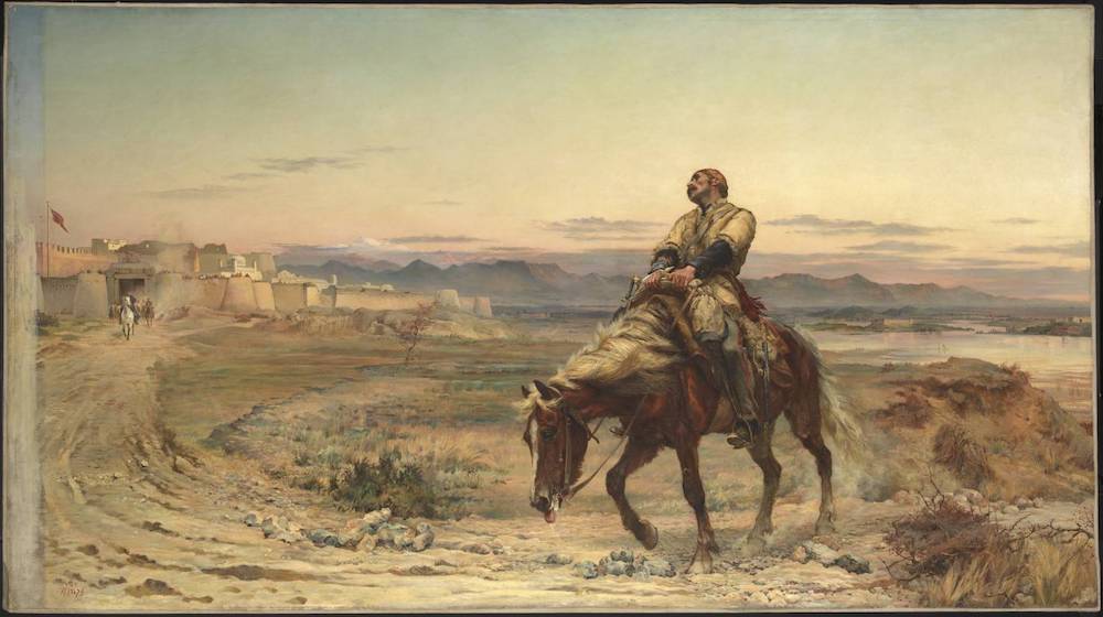
The Remnants of an Army by Elizabeth Thompson (Lady Butler), 1846-1933. 1879. Oil on canvas. 132.1 x 233.7 cm. Courtesy of Tate Britain. Click on image to enlarge it
When Shah Shoojah, under the protection of the victorious British army, made his formal entry into his former capital of Cabul, the Afghan war appeared to be at an end. But the disasters which subsequently befell the British forces in Cabul, isolated and surrounded by hostile tribes — the assassination of Sir Alexander Burnes and Sir William Macnaghten, the convention under which Major Pottinger and Captains Laurence and Mackenzie were delivered up as hostages to Akhbar Khan, and the massacres which ensued—are also matters of history. Twenty-six thousand men, women, and children fell in the rocky defiles and mountain gorges of Afghanistan, partly under the incessant attacks of the Afghan troops and the wild hill tribes, but more from hunger and the deep snows and wintry blasts of that region. Of all that host only one, Dr. Brydon, made his way alive to Jellalabad, bringing the news that the army of Cabul had ceased to exist. Seven or eight only of the survivors were taken prisoners; the rest were killed. The campaign of 1842, conducted by General Pollock and General Nott, vindicated the superiority of British arms, and compelled the Afghans to submit to the terms imposed on them. It is scarcely probable that they will be enabled to resist the military power of our Indian Empire, backed by that of England, upon the present occasion. [326-27]
Last modified 23 May 2017